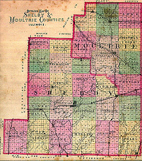
Chapter III

GEOGRAPHY, AGRICULTURAL RESOURCES AND RAILROAD FACILITIES OF SHELBY AND MOULTRIE COUNTIES


THE COUNTY OF SHELBY...

MOULTRIE COUNTY

RAILROAD SYSTEMS

A STATEMENT OF MILES OF TRACK AND ASSESSED VALUE OF R. E. PROPERTY OF MOULTRIE AND SHELBY COUNTIES


THE COUNTY OF SHELBY lies between the 39th and 40th parallel of latitude, and the third principal meridian forms a small portion of its western boundary. It lies a little south of the cen tre of the state, and is bounded as follows:

On the north by Christian, Macon, and Moultrie; east by Moultrie, Coles, and Cumberland; south by Effingham and Fayette; and west by Montgomery and Christian counties. It is thirty miles from north to south , and its greatest breadth thirty-six miles from east to west. Its area is about 800 square miles, or 512,000 acres.

Population. - The population of the county, according to the census of 1870, was 25,476, and in 1880 is given at 29,951, and is princi pally composed of persons of English, Irish, German, and French extraction, with a few colored persons. The population by townships is as follows:

TOWNSHIPS

  • Shelbyville - 4,105
  • Dry Point, - 2,326
  • Prairie - 2,163
  • Big Spring - 1,983
  • Windsor - 1,952
  • Cold Spring - 1,651
  • Oconee - 1,607
  • Ash Grove - 1,563
  • Tower Hill - 1,479
  • Holland - 1,463
  • Rose - 1,385
  • Richland - 1,143
  • Moawequa - 1,121
  • Flat Branch - 1,080
  • Rural - 1,045
  • Ridge - 1,015
  • Oka w - 913
  • Pickaway - 834
  • Penn - 614
  • Todd's Point - 509
  • 29,951

Shelbyville, the capital of the county, is situated in township 11 North, Range 4, on sections 7 and 18 -- it derived its name from the county, and it from Isaac Shelby, an officer of the revolution. Its location is near the center of the county, and on the line of the Indianapolis and St. Louis Railroad. The Kaskaskia river in its sinuous course passes along the eastern boundary of the city, furnishing a most excellent drainage. The city by rail is one hundred and ten miles northeast from St. Louis, seventy-nine west from Terre Haute, and one hundred and fifty miles west of Indianapolis.

Land Surface - The land surface is divided between timber and prairie, the greater part being originally covered with a luxuriant growth of timber, a large portion of which has, ere this, given way before the axe of the pioneer and old settler. The surface in different localities is rather undulating. There are occasionall y small hills or bluffs adjacent to the streams, principally along the Kaskaskia river and its tributaries.

Soil and Agriculture - This county contains within its limits some of the best, richest and most productive soil in the state; especially is it so of the North-western section of the country. Agricultural pursuits are in fact the leading employments of the people, and the rich returns which it brings to those engaged in them, promise to attract strangers, and reward all who devote labor to it. The leading staple products are Indian corn, wheat, oats, potatoes, hay, tobacco, and sorghum; the productions are so various as to warrant the assertion that no year or season can occur in which the prudent husbandman will be completely disappointe d in his hopes. Every desirable fruit, every useful grain, every nutritive grass is found here growing to perfection; industry may grow rich by the proper use of its resources, and domestic comfort, and even luxury, may find ample opportunities to gratif y every reasonable desire. Its intelligent and enterprising people may advance in wealth, in knowledge, in refinement, and in all the arts and blessings of life. No spot is more favored, and none is more full of promise of future growth and influence.

Drainage and Climate - It is drained by several streams -- the Kaskaskia river running nearly through the center of the county, from north to south, is the largest, and drains the greatest area of country; it enters the county on a line almost be tween Windsor and Okaw township, and runs in a south-westerly course, in a zig-zag manner, through Windsor, Okaw, Shelbyville and Rose townships, touching Holland slightly, on the east, and entering Dry Point on section 3, and leaving it on section 15, (t ownship 9-3). Its principal tributaries are Robinson's, Sand, Coon, Jordan, Richland and Brush creeks. Robinson's creek rises in Pickaway township, and gathering numerous affluents, drains a large district and passes through Ridge and Rose townships, an d mingles its waters with the Kaskaskia on section 34. The north western portion of the county is drained by Long Grove Branch and Flat Branch and their tributaries; the south-western section of the county is admirably watered and drained by Beck's, Opos sum, Stone and Mitchel's creeks, while the south-eastern part of the county is drained by the Little Wabash river, Rattlesnake, Copperas, Green and Wolf creeks and their tributaries; each of these streams has its affluents, so that the entire surface of t he county is well watered and drained. In portions of the county good water is. afforded by copious springs and small lakes. The surface of the county is higher as a rule than the adjacent counties, as may be inferred from the fact that so many streams have their source here. The high grounds are the water sheds between the creeks. The natural and artificial groves, the fringed banks of the water-courses, the smiling farms, with their fields of maize and grain, and herds of cattle, all go to form a pi cture of surpassing loveliness. But little of the land is too flat for drainage, or broken for tillage, and hence the greater portion is susceptible of cultivation, and affords the widest application for machinery. The climate is healthful, and is a hap py medium between the extremes of heat and cold.

Political Divisions of the County - Shelby county is divided into twenty municipal townships, or voting precincts, viz.: Big Spring, Ash Grove, Prairie, Richland, Windsor, Holland, Shelbyville, Ok aw, Todd's Point, Dry Point, Rose, Ridge, Pickaway, Penn, Cold Spring, Tower Hill, Rural, Flat Branch, Moawequa, and Oconee; of this number only eight are congressional townships; the balance are fractional, some more and some less than full congressional townships. The southern tier of precincts each comprise one and a half townships, or fifty-four sections of land.


MOULTRIE COUNTY WAS ORIGINALLY a part of Shelby and Macon counties, out of which it was formed. It is bounded on the north by Macon and Piatt

Page 30


east by Douglas and Coles, south by Shelby, west by Shelby and Macon counties. It is situated a little south-east of the center of Illinois, and was organized out of the north-eastern portion of Shelby and the south-east corner of Macon, and was named in honor of William Moultrie, a brave and gallant soldier of the Revolution. The greatest length of the county from the north to the south line is about twenty-three and a half miles, and its greatest breadth from east to west is eighteen miles. It contai ns 218,524 69-100 acres, or nearly 342 square miles, divided into sections, many of which contain more and some less than 640 acres.

Sullivan - The capital of the county is situated a little south-east of the center, and at the crossings of the P. D. & E. and W. St. L.& P. railroads. It is quite a thriving and enterprising place.

Population - The population of the county as shown by the census of 1880, is 13,539. The population of 1870 was 10,385, showing an increase in the last ten years of 3,154 persons. Moultrie is peopled by the representatives of several nations, forming a mixed population. Here the English or Anglo-Saxon finds his home. Also representatives of the Celtic and Teutonic races are found within its borde rs. Here too are met with, the impassioned and freedom loving Frenchmen, and the honest and energetic Swedes, have also made their homes amongst us --- also a few families of the colored race.

Topography - The general surface of this county is flat or level; however, in some parts it is gently undulating, and in the regions of the various water courses the land is more broken; particularly is this the case along the Okaw (or Kaskaskia) and West Okaw creeks, where there are low sand and clay hil ls, and in several places they rise to a considerable height above the surrounding surface. Originally there were about 65,920 acres of timber land in belts ranging from two to six miles wide along the various streams, much of which has been cleared and m ade into farms, yielding annually large crops of important cereals. The larger part of the county consists of prairie, the timber being confined to belts along the Okaw and West Okaw creeks, and their tributaries. In the southern part where it predomina tes, there is some timber of excellent quality. In the northern tier of townships there is only a narrow strip along the West Okaw, in Lovington township, there being no natural timber in either Dora or Lowe.

Hydrography - The principal natural water course in this county is the Okaw (or Kaskaskia) creek -- or river, as it is called lower down. It enters the county on the east side of Section 24 in East Nelson township. Its course through this county is north, west, due west, and south-west, and after making numerous crooks and turns through East Nelson, and the southern portion of Sullivan township, it passes out of this county into Shelby near the southwest corner of Section 31, (Tp. 13, R. 5). Jonathan Creek heads in Section 3, T. 14, R. 6, and meanders in a southerly course, and has its confluence with the Okaw on Section 17, East Nelson township. It has several small affluents. Whitley Creek, which flows into the Okaw in the south-eastern corner of Sullivan township, enters the county on the north-east corner of Whitley township, and has several tributaries which drain the south-eastern part of the county. The West Okaw, which drains the more central and western portions of the county, rises in Piatt county about one mile and a half north of the county line between Moultrie and Piatt. In its course it flows in a south-westerly direction, through Lovington, north-west corner of Sullivan township, along the east side of Marrowbone, touching the north-east corner of Shelby county, wher e it changes its course to a south-eastern direction, and mingles its waters with the Kaskaskia on Section 31, (13-5). Marrowbone creek, the largest tributary of the West Okaw, rises in the north-western part of Dora, and with its affluents drains the so uthern and the central portions of Marrowbone township. Welbourn creek flows across the south part of Marrowbone township, from west to east, and empties into the West Okaw. Thus it will be seen that this county is quite well provided with natural drain age.

Tile Draining is being introduced in parts remote from these water-courses, and in time, when the system of draining becomes better understood, and generally applied, it will result in great good to the agricultural interests of the county. There are many small and several large ponds and lakes in the county, two or three of which contain several hundred acres each, which might in this way be drained and the land redeemed and cultivated

This tiling, which has been in general use only some five or six years, is made out of a species of fire clay, of which extensive beds are found in the county. The average cost of laying tiling is twenty-five cents per rod; the average depth to which it is laid in the ground is three and a half feet. The pric e of tiling varies according to diameter, as follows:

  • Tiling 3 inches in diameter, per 1000 feet, $12
  • Tiling 4 inches in diameter, per 1000 feet, $15
  • Tiling 5 inches in diameter, per 1000 feet, $18
  • Tiling 6 inches in diameter, per 1000 feet, $35
  • Tiling 7 inches in diameter, per 1000 feet, $45
  • Tiling 8 inches in diameter, per 1000 feet, $55
  • Tiling 10 inches in diameter, per 1000 feet, $90

As the benefits resulting from tile draining become more appreciated, and its importance more fully realized, by the farming community generally, it will be still more extensively used, and millions of wealth thereby added to the agricultural interests of the state.

The Resources, Soil, and Agriculture - The resource s of Moultrie county are chiefly agricultural; the manufacturing interests, according to recent statistics, employ only about one hundred and twenty-five thousand dollars capital. There are several brick and tile factories, wagon and carriage factories, flouring and saw mills, and one woolen mill. The amount of capital invested in the respective enterprises is fully set forth in the statistics in the chapter on civil history.

The soil of this county is somewhat diversified; there is, however, very li ttle land that is not susceptible of cultivation, and that will not yield rich returns to the agriculturalist. The soil of the prairie lands, and these constitute the greater portion of the county, especially on a line due east and west, and north of Sul livan, are composed of a black, peaty loam from three to ten feet deep, and commonly termed "vegetable mold." On the Okaw hills or bluffs the soil has a light yellowish color, with reddish brown clay containing sand and gravel intermixed. The arenaceous and argillaceous soil of the timber changes rapidly into the deep, rich black soil of the prairie.

In all ages, and in all conditions of society, and, nations, agricultural pursuits have been the most necessary and important employment of ma nkind. From the broad bosom of mother earth, families and people of every clime have drawn their sustenance. In the same proportion that the tiller of the soil thrives and prospers is the success of the merchant, the manufacturer, and the artisan. The surplus products of his labor form constant additions to the wealth of the state, and help to swell the capital of the nation. When farming fails, famine flourishes, poverty prevails, commerce ceases, and progress is paralyzed. The chief occupation of t he people of Moultrie county is farming and stock-raising. Most excellent corn crops are annually raised. The

Page 31


average yield of this cereal is about sixty-five bushels per acre, and sometimes far exceeding this number.

Oats, barley, and rye grow luxuriantly, rarely failing to yield bountiful crops. The potato, turnip and all other garden vegetables and tuberou s plants, are successfully cultivated. The fruits and berries of all varieties, such as apples, pears, peaches, plums, grapes, currants, grow well, and in favorable seasons produce more than enough to meet the demands of the local markets. But wheat, es pecially the winter variety, is considered a very uncertain crop. However, for the last two years wheat has done well in this county, and has made a favorable average with other counties in this part of the State. The principal cultivated grasses are: b lue grass, timothy, red-top, orchard-grass, and clover. These afford rich and nutritious pasturage for stock, and an excellent quality of hay for the market. The acreage of pasture and meadow is being yearly increased, indicating a tendency on the part of farmers to take advantage of the great facilities nature has here furnished for stock raising. The domestic animals are of improved breed. The horses, cattle, sheep and hogs are of far finer quality now than they were a few years ago, showing progres sive spirit and enterprise on the part of farmers in keeping with all other branches of industry.

Political Divisions - This county is divided into eight townships; a more extended notice of which may be seen in a carefully prepared history of each, in another part of this work. . The names of the townships are as follows: Whitley, East-Nelson, Jonathan-Creek, Lowe, Sullivan, Lovington, Marrowbone, and Dora.

Timber - The native kinds of timber in Shelby and Moultrie counties, are full y set forth in the chapter on the Flora, and hence demand but brief mention here. The largest quantity of timber found in the two counties is adjacent to the water-courses, in the southern tier of townships; in the south-western part of Shelby, was origi nally mostly covered with a heavy growth of the several varieties of oak, hickory and elm, linden, wild cherry, honey locust, black walnut, sycamore, hackberry, and cotton wood. The same will apply to Moultrie county, in the valleys and hills adjacent to the Okaw, Whitley, West Okaw creek and their tributaries; and occasionally the timber line would jut out into the level or prairie land. Fine belts of timber originally skirted the banks of all the streams in these counties, furnishing an adequate suppl y of timber for fencing and fuel. Artificial groves and belts, consisting chiefly of hard and soft maple, elm and fruit trees, and the Osage orange for hedges, have been planted on the prairies, and add much beauty by their presence to the landscape.

< HR>RAILROAD SYSTEM

Transportation Facilities.

Perhaps the most important factor in the business development and prosperity of a city or county, is its railroad communications. At least it is safe to assert that such has become a demonstrated fact with regard to Shelby and Moultrie counties. A retrospection of their history since the advent of railroad facilities, will convince the careful observer of the immense benefit resulting from the introduction of this essential adjunct of commercial ente rprise. We here insert brief sketches of the railroads traversing these counties.

Illinois Central B. B. -- The main line of this road enters Shelby county on section 19, township 14, Range two east, and traverses the north-western corner of th e county in a south-westerly direction, leaving the county on section seven, in township 13-2. Its course is then through Christian county, in the same direction, until it strikes section 4, (township 10-1), Oconee, when after crossing the line of sectio ns 8 and 17, its course is due south. The stations on the line of this road in Shelby county, are the flourishing town of Moawequa, in the north-west corner of the county, and Oconee in the south-west part of the county, from which point considerable shi pping is done.

The Chicago Branch of this road traverses a little over four miles of the south-east corner of Shelby county, passing through the village of Sigel in Big Spring township. In September, 1850, Congress passed an act, and it was approved b y President Fillmore, granting an aggregate of 2,595,053 acres to aid in building this road.

The act granted the right of way, and gave alternate sections of land for six miles on either side of the road. The grant of land was made directly to the sta te. On the 10th of February, 1851, the legislature of Illinois granted a charter to an eastern company, represented by Rantoul and others, to build it, with a capital stock of $1,000,000. The legislature, in granting the charter, and transferring to the corporation the lands, stipulated that seven percent of the gross earnings of the road should be paid semi-annually into the treasury of the state forever. This wise provision, in lieu of the liberal land grant, yields a handsome annual revenue to the s tate. This road has a total length of 706 miles, connecting Cairo with Chicago and Dunleith, or from Cairo to Centralia 112 miles, and from Centralia to Dunleith 341 miles. This road is one of the great trunk lines of Illinois and the Mississippi Valley; its principal leased line in this state is the Gilman and Springfield road, and with its Iowa division, running from Dubuque to Sioux city, serve to mark it as one of the principal roads of the west, and connects Chicago with St. Louis by the Vandalia ro ad. The first ground broken toward the building of this road in this county was in 1853. And the cars were running the following year, and then Moawequa and Oconee stations were located.

Indianapolis and St. Louis Railroad.

(Formerly the Terre-Haute, Alton and St. Louis railroad). Its general offices are located at Indianapolis, its eastern terminus; and St. Louis being the western termini, the length of track from either termini is 261 miles. The road-bed is of substantia l build, well ballasted, tied and ironed. It enters the state of Illinois in Edgar county, and the principal towns which it passes through in this state, are Paris, Charleston, Mattoon, Shelbyville, Pana, Hillsboro, Litchfield, Bunker Hill, Alton and Eas t St. Louis. The line of the road is laid through a very fertile district of the state, and it receives a fair proportion of the traffic.

The act passed by the Legislature of Illinois to incorporate the Terre-Haute and Alton railroad company went into effect January 26th, 1851. An extension from Alton to St. Louis was subsequently built, and the road was then for several years known as the Terre-Haute, Alton & St. Louis R.R. It strikes Moultrie county first on section twenty-four, Whitley townshi p. Summit, a station in this township is about a mile and a half west of the county line; the general direction of the road through Shelby county is slightly south-western, passing through Windsor, Richland, Shelbyville, Rose, and Tower Hill townships. The principal station in the latter county is Shelbyville. At Windsor it crosses the line of the Wabash, St. Louis and Pacific R. R, and at Tower Hill it furnishes communication with the north and south, through the 0. & M. road. The I. & St. L. and 0. & M. run on parallel lines about three miles from Tower Hill to the west line of the county. This is by far the most important road in Shelby county. It was completed same date as the Illinois Central.

Peoria, Decatur and Evansville R. R.

The first effort made to build a railroad through Moultrie county,

Page 32


was that in connection with the Shelbyville and Tolono road, but only a survey of the line and a little grading was done when the project failed.

The P. D. & E. road is a consolidation of the Pekin, Lincoln and Decatur, and the Decatur, Sullivan, and Mattoon railroads. The former of these two roads was chartered in 1861, and the charter was amended in 1865. The road was constructed in 1871, from Pekin to Decatur, 67 miles. and was leased by the Wabash. The (D. S. & M.) was chartered the sa me year (1861), and in 1872 was completed from Decatur to Mattoon, a distance of 43 miles. Subsequently these two roads, as before stated, were consolidated and now form the P. D. and E. R. R., which secures to the county a north-western and south-easter n line of transportation; the northern terminus being Peoria, and the present southern, Parkersburg, making the road, as extended, 192 miles in length. Through the efforts of some of the enterprising citizens, they united with the people of Decatur and M attoon, and aided by Mr. W. M. Stanley, then representative in the legislature from this district, procured a charter for the D. S. & M R. R., and the Board of Supervisors of Moultrie county subscribed $80,000 in bonds. These bonds were issued Decem ber 31, 1872, bearing interest at the rate of 8 percent per annum, and to mature January 1, 1883. All but about $6,000 of these bonds have been paid, and the whole amount will be cancelled before the date of maturity. This road enters Moultrie county in Dora township at Dalton City, and it traverses the county in a south-easterly direction, through Dora, Marrowbone, Sullivan, and East Nelson townships, and passes out at Coles station, in the north-eastern corner of Whitley township. The most important s tation is Sullivan, at which place it crosses the line of the Wabash, St. Louis, and Pacific.

Illinois Midland R. R.

Which is a consolidation of the Peoria, Atlanta, and Decatur and the Paris and Decatur railroads. It was c onstructed in the year 1872, from Peoria, via Decatur to Terre Haute Indiana, Peoria and Terre Haute being the termini, and the entire length of the road is 176 miles, of which 168 are in Illinois. This road enters Moultrie county from the west, in the n orthern part of Dora township, on the line dividing the sections ten and fifteen, and extends due east to Lake City, where it diverges from a straight line in a south-east direction to Lovington, at which thriving and enterprising town it crosses the Waba sh, St. Louis and Pacific R. R. Here again its course changes and it traverses the balance of the county due east, crossing the county line at Arthur on Section 25 in Lowe township. Lake City, Lovington, Williamsburg and Arthur are the stations in this c ounty, Lovington being the most important.

Moultrie County has done much to foster and encourage her railroad system. Her people have been liberal, having donated the right-of-way, and voted moneys to aid in the construction of the roads.

The total railroad bonded indebtedness of the county is at present, $281,000, as follows:

  • $6,000 of the subscribed $80,000 to the P. D. & E. R. R.
  • $75,000 donated by vote to P. D. & E. R R.
  • $200,000 donated by vote to Chicago & Paducah, now W. St. L.
  • $281,000 Total.

The $75,000 was issued in one thousand dollar bonds, November 1, 1871, drawing 8 percent interest, and the $200,000 in one thousand dollar bonds, issued May 27, 1872, bearing ten percent in terest. In as much as there is believed to have been some irregularity in the manner in which the latter donations were made, the constituted authorities of the county propose to contest the legality of said bonds. In addition to the above there is a to wnship railroad indebtedness of $42,000, viz: Sullivan tp. $30,000, Lowe, $12,000. These bonds are also in litigation.

Wabash, St. Louis and Pacific R. R.

(Formerly Chicago and Paducah R. R.) This road was built through Mou ltrie and Shelby counties in 1873 and '74. It has since passed into the hands of the Wabash, St. Louis and Pacific. Believing it will be interesting to our readers, we give a brief description of this great corporation, whose future prosperity is so int imately intertwined with the growth and development of these counties. Great Western, whose name has since been successively changed to Toledo, Wabash and Western and Wabash, St. Louis and Pacific, the last of which it still bears. The Great Western was an extension of the Northern Cross Railroad, and was completed to Bement, north of Moultrie county, and the cars running in April, 1854. More than to any other this immediate section of the state owes the subsequent rapid development of its agricultural and other resources. Its line passes through some of the finest portions of Illinois, Indiana and Ohio. It soon became the popular highway of travel and traffic between the East and the West. Under its new name -- Wabash, St. Louis and Pacific -- and m anagement, it has rapidly extended its lines east and west of the Mississippi river, comprising at present two great divisions, the eastern and western.

  • Total miles east of the Mississippi river - 1381 miles.
  • Total miles west of the Missis sippi river - 777 miles.
  • Grand total Eastern and Western Divisions - 2158 miles.
The Chicago and Paducah branch of this road enters Moultrie county in the north-east corner of Lovington township, and its general course is almost due south . It traverses Lovington township, crossing the Illinois Midland R. R. at the town of Lovington. It passes on through Sullivan tp. and at the City of Sullivan crosses the line of the P. D. & E. R. R. Thence through the north-west corner of Whitley t p., and crosses the section lines between Whitley and Windsor townships, when it enters Shelby county, and at the town of Windsor crosses the I. & St. L. R. R., and passes on down through Richland and Prairie townships. The stations below Windsor are Strasburg, Hebron, and the thriving village of Stewardson. The road crosses the south line of Shelby county on Section 15, (tp. 9-5), Prairie township. By this road and the I. & St. L, the two counties are linked together by bands of iron. The W. St. L. & P. is the most important road in the two counties, and is the great North and South line, connecting with the principal northern and southern cities. The principal lines of this road have steel rail tracks, well ballasted road-beds, and alto gether constitute one of the greatest railroad systems in the West.

Springfield Division of Ohio and Mississippi R. R.

This read enters Shelby county on the west line of Section 19, Tower Hill township, and its course is due east until it reaches the village of Tower Hill, which is the most important station on the line of this road in Shelby county. Here the line diverges from an eastern to a south-eastern course; and traverses the townships of Tower Hill, Cold Spring and Dry Point. The stations in this county are Tower Hill, Lakewood, Cowden and Holliday -- the latter village is on the dividing line between Shelby and Fayette counties. This road was formerly known as the Springfield and Pana R. R., afterwards as the Spr ingfield and South-eastern R. R., and on the first of April, 1875, it was sold to the 0. & M. R. R.

Page 33


Company. It was built under a charter obtained in 1865, and completed in 1870. The first construction train to run from Pana to Springfield was on the 28th of October, 1869. The first through train from Beardstown to Shawneetown, was run on the 28th o f March, 1872. This road does a fair business, and its influence has been greatly felt in developing the resources of the south-western portion of the county.

We append some statistics relative to the above described roads which will doubtless be of i nterest to the reader.


A STATEMENT OF MILES OF TRACK AND ASSESSED VALUE OF R. E. PROPERTY OF MOULTRIE AND SHELBY COUNTIES.

MOULTRIE COUNTY
Names of Roads Main track inclu-
ding right of way.
Side or turnout
track.
Total value of R.
R. property as-
sessed by the
State Board of
Equalization.
Length. Length.
Miles. Feet. Miles. Feet.
Illinois Midland.
Indianapolis and St. Louis.
Peoria, Decatur and Evansville.
Wabash, St. Louis and Pacific.
15
5
23
22
4515
 
 
3218
1


1029
1235
2794
5215
$49,407
31,363
76,051
118,867
Total, 66 2453 2 4993 $275,688
SHELBY COUNTY
Indianapolis and St. Louis R. R.
Wabash, St. Louis and Pacific.
Ohio and Mississippi.
Illinois Central R. R.
27
19
17
16
 
2912
3866
2640
1
1
 
 
5071
1094
3549
 
$135,501
51,517
79,494
Pay no tax.


|| Return to Main Site Index ||