1
Whitley Point
Whitley Point, the first settlement in what is now Moultrie County, Illinois, dates
back to the autumn of 1826.* John Quincy Adams was President of the United States.
Illinois had become a state e
ight years earlier, in late 1818, with its capital at Kaskaskia. (3)
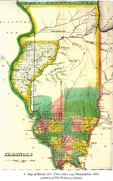
By 1826, European immigrants and their descendants had settled less than one-third
of the state--the southwest, adjacent to the Mis-
* Very little survives of the early history of the Whitley Point settlement. Not much was written down at the time. And on November 25, 1864, the first courthouse of
Moultrie County, in Sullivan, was destroyed by fire, burning "nearly all of the Circuit Court Clerk's and many of the County Clerk's records." (Inventory of the County Archives of Illinois, No. 70, Moultrie County, 1941, p. 86.) The earliest Moultr
ie County court records preserved date from 1872; and the earliest Circuit Court records date from 1849. (Inventory of the County Archives, 1941, pp. 155-156, 182-183; see also Pease, T. C., The County Archives of the State of Illinois, 1915
, pp. 484, 492.)
In 1881, a Combined History of Shelby and Moultrie Counties, Illinois (referred to here as the Combined History), was published by a Philadelphia Publishing house. Consisting of 333 pages of general state and local history, interspearsed wit
h personal and family histories and pictures of successful men and prosperous farms, this work was a commercial venture based on the recollections of leading citizens, or at least those who knew about the project and volunteered their information to the e
ditors. Although we are fortunate to have it, this book is limited as a resource because it was written over fifty years after the initial settlement, and the recollections contained in it depend on the accident of which of the early families had survivor
s in the county who chose to cooperate. Also, as a leading scholar of this period has written, the reminiscences preserved in such county histories are usually subject to one of two tendencies: either they emphasize the "harsher or unrealistic viewpoint o
f pioneer life described in all its primitiveness," or they are expressed "in romanticism and overidealization of the good old days." (Buley, The Old Northwest Pioneer Period, 1815-1840, pp. 138-139.)
For a description of the other principal sources of the early history of Whitley Point and Moultrie County, see endnote 3.
(Page 3)
sissippi and lower Kaskaskia rivers,
and the southeast, along the Wabash. The northern two-thirds consisted largely of
uninhabited treeless prairies, with a few wooded valleys along streams--and was "the domain
of the Indian and the fur trader." (4)
Most of the Illini nation (a branch of the Algonquin family) found by the French one
hundred fifty years earlier had disappeared, although remnants of the Kaskaskia,
the Peoria and the Kickapoo remained in southern and central Illinois. To the northwest
,
the Sauk and the Fox, and a few Winnebago lived along the Rock River and the Mississippi.
In the northeast, including what is now Chicago, were found the Pottawatomi and associated
groups. Although there was relative peace between the Indians and whi
tes in Illinois, most of the Indians had been aligned with the British during the War of
1812; and many of the settlers--particularly those who had lived during the post-Revolutionary
War era in Kentucky or other parts of the Ohio River valley--had vivi
d recollections of the death and destruction inflicted by Indian raiding parties.
The largest towns in Illinois in 1826 were Kaskaskia, the first state capital, and
Shawneetown, a port of entry for immigrants and the site of the land office for
the
southeastern part of the state. To the north, where the Chicago River ran into Lake
Michigan, Fort Dearborn had been wiped out during the recent war, but a military post had
been reestablished in 1816; and it was now a small wilderness station--a
fort, one
or two makeshift hotels or taverns, and a few primitive cabins, accommodating perhaps
a few dozen people--that served to protect and shelter the government officials who dealt
with the Indians, and the private traders who supplied goods to th
e Indians in return
for furs, skins and other articles. Chicago was not officially surveyed and platted until 1830. (5)
At the time of statehood in 1818, all the land in central Illinois--including what
is now Moultrie County--was claimed by the Kickapoo Indians, who from 1811 to 1815
had joined with Tecumseh and allied tribes to resist American encroachment on Indian
l
ands. In the Treaty of Edwardsville, signed July 30, 1819, the Kickapoo gave up their Illinois
claims in return for lands on the Osage River in Missouri. (6) The Illinois land then
became United States g
overnment land, to be surveyed into rectangular townships and
sections and then sold
(Page 4)
through government land offices--first through public auction
and later, if there was no auction buyer, through private sales. However, many settlers,
including the first settlers in Moultrie County, were "squatters" who occupied the
land they wanted b
efore legal title had been perfected.
The first Moultrie County settlers were John S. Whitley and his wife, their six sons
and two or three daughters, and their families--totaling about 35 people. The Whitley
family had migrated west from Virgi
nia with stays in North Carolina and Tennessee
before arriving in southern Illinois about 1811. (7) The Whitleys moved to what is now Moultrie
County in 1826. Most of the county land at that time was pra
irie country--part of
what some called the "Grand Prairie" of central and eastern Illinois. The Whitleys
settled on land adjacent to a creek which is still known as Whitley Creek,* (3) in the north
hal
f of Section 12 of Township 12, about one quarter mile west of what is now the
dividing line between Coles and Moultrie counties. (8) John Whitley Sr. and his sons
were reportedly sportsmen; they kept a
number of fine thoroughbred racing horses, and were
said to indulge more than occasionally in gambling and fighting. (9)
The place selected by John Whitley had many advantages. Wood and water wer
e at hand,
and game was plentiful--including deer and turkey. Bears, wolves, panthers, and wild
cats were also encountered. Because of the good hunting, Indians frequented the area.
Indeed, in the winter of 1826 27, after the Whitleys first arrived, In
dians maintained
a large camp consisting of about 90 lodges a few miles south of the Whitley settlement
in what is now Shelby County. These Indians were considered to be friendly by the
settlers, with whom they maintained a lively social intercourse--i
ncluding occasional
contests of horse-racing, shooting, and athletic events. (10)
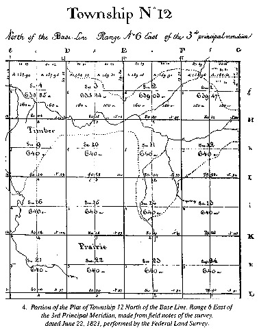
The first survey of the area had been performed by federal land surveyors in 1821.
The field notes of the first
surveyors of Section 12
* Whitley Creek runs east to west and until recently joined the Okaw, which flowed southwesterly and became the Kaskaskia, which in turn flowed into the Mississippi. Today, thanks to federal flood control projects damming the Kaskaskia, Wh
itley Creek flows instead into Lake Shelbyville. Before its junction with the Okaw (now the lake), Whitley Creek is joined by two creeks--Crabapple (from the north), and Lynn, or Linn (from the south), each thought to be named for the trees (Linn is a con
traction of Linden) that then grew along their banks.
(Page 5)
in Township 12N, Range 6E,* where the Whitleys settled five years later, refer to "gently rolling" prairie, with
"first rate" soil, and walnut, oak, elm and mulberry trees. (11) The plat prepared from th
e
surveyors' field notes shows the land adjacent to a creek and covered with timber,
which juts out into the surrounding prairie. (A portion of the plat based on the
original 1821 survey is reproduced as Illustration 4 on p. 7.)
The Whitley fa
mily settled near a point where the timber adjacent to the creek extended
into the prairie. Hence, the name of the settlement--Whitley Point. In 1826 the United
States was not selling land in this part of the state, so the Whitleys "squatted," and did n
ot obtain legal rights to the land until 1830. The township in which the
settlement was located is today called Whitley Township; and an east-west road through
the township was for many years known as the "old Whitley road." (12)
The Whitleys' decision to settle in timber land close to a river or creek followed
the pattern set by most settlers in central and eastern Illinois during this early
period. The pioneers of the Illinois frontier were
hunters and woodsmen, who lived
by the rifle and axe and whose cultivation was generally limited to small plots of prairie
adjacent to the timber, where the sod was not as tough and the grass not as long
as on the larger prairie
s. (13) The timber provided fuel and wood for the cabins, fencing
materials and shelter for both men and animals from the heat of the summer and the prairie
winds of winter. In some places and during some periods of the year,
the rivers pro-
* To deal with problems arising out of the inadequacy of "metes and bounds" descriptions, such as had been used in Kentucky, Congress in the Land Ordinance of 1785 provided for a uniform federal land survey. In central Illinois, the main n
orth south line was the Third Principal Meridian, an arbitrarily chosen line running due north from the mouth of the Ohio River on the Mississippi. The main east west baseline ran across southern Illinois and Indiana. Each township consisted of 36 square
mile sections, numbered 1 through 36. The Whitley settlement lay in Township 12 N (north of the baseline), and Range 6 E (east of the Third Principal Meridian). Although townships existed for purposes of property descriptions, the township form of county
organization--with an elected board of supervisors as the county governing body, rather than a county commissioners' court or county court--was not adopted in Moultrie County until 1866. (Inventory Of The County Archives Of Illinois, No. 70, p. 55.
)
(Page 6)
(Page 7)
vided
an avenue of transport; and in any event, water could more easily be obtained from a spring or nearby stream than from a well sunk through thick prairie sod.
During the first period of settlement in the 1820's and early 1830's, most settl
ers
believed the prairies were so inhospitable that they would never be settled. Having
no experience with prairies, many simply assumed that because large trees grew near
the rivers and creeks, the most fertile soil must be there. Also, the plows used
at that
time, although adequate for conditions in the East or in Kentucky, would not cut
through the thick roots of prairie grass. It was only later that new plows were developed, and experimentation demonstrated that the fertility of the prairie soil
would amply
repay farmers for the hard work of breaking the tough sod. (14)
In 1826, the Whitley Point settlement was part of Fayette County, which then covered
a large part of central Illinois
, from the Illinois River on the north, to the new
State capital of Vandalia on the south. However, this did not last long, as the legislature on January 23, 1827, created Shelby County, with the county seat to be called
Shelbyville. In April 1827, John Whitley, Jr., son of the first settler, was elected
one of three members of the County Commissioners' Court of the new county, for which
he received $1.50 for each day's service. Moultrie County was created largely out
of Shelby
County 16 years later, in February 1843.
After the Whitleys in 1826, the next major influx into the Whitley Point area occurred
two years later, in late March 1828, when Isaac and Emsey Waggoner and several sons
and daughters and th
eir families arrived in two covered wagons from North Carolina.
Isaac, born September 11, 1761, in South Carolina, had served as a private in the state
militia during the Revolutionary War. Soon after the war, he married Emsey Holeyfield,
and they move
d to North Carolina where they lived almost thirty years before relocating to Illinois. (15) Their sons were George, Amos, Elisha and Gilbert, and the daughters
were Emsey and Polly, who came with her hu
sband Noah Webb. Two other sons, John and
Isaac, Jr., arrived with their families a few months later. With 45 members, the
Waggoner group was larger than the Whitleys. They settled five miles west of the Whitley
cabins near a creek later known as the W
aggoner branch, which flowed into
(Page 8)
Whitley
Creek near its junction with the Okaw. (16) Upon their arrival, the Waggoners immediately
built cabins and prepared for the coming growing season by breaking the ground with
the help of Samuel
Lindley and his ox teams. (17) Unlike the Whitleys, who moved a few
miles away to the vicinity of Cook's Mill in nearly Coles County in the mid-1830's,* the Waggoners stayed and their descendants have po
pulated the county throughout the intervening 170 years. (18)
One of the patriarch Isaac Waggoner's granddaughters--Mrs. Martha Scott, a daughter
of Amos Waggoner and wife of Andrew Scott--later
wrote about the family's arrival
at the Whitley Point settlement in the spring of 1828:
We had one large crooked bed wagon, either four or six horses, I do not know which.
I think Father and Uncle Elisha did most of the driving of the big wagon. They had
a saddle on one of the horses that was hitched to the wagon and rode it and drove
the
others. Grand-father had a carry-all for him and Grandmother to ride in; sometimes they
would take some of the children to ride with them....
We did not meet many travelers, no railroads then, and but few good roads. Once in
a while we would m
eet the stage coach with a
* When John Whitley died sometime in the winter of 1838 39, his Administrator brought suit before a Whitley Point Justice of the Peace to collect amounts owed to Whitley's estate. (Whitley Point Record Book, infra, pp. 96 97.)
(Page 9)
few people in it. They traveled in a
hurry and sounded their bugle in time for us to give them the road....
Finally, we landed on Whitley Creek, Shelby County, Illinois, I think about the last
of April 1828. There were a few peo
ple there at that time. The Whitleys were there,
and a few others. The country was wild, a few little cabins with two or three acres
in cultivation, land was not in market yet.
We thought the prairies never would be settled. Grandfather lived i
n a little cabin
on the place where Mr. Little lived afterwards. The first year after that he settled
across the branch southeast of there. Uncle George settled on the place he lived
on until he died. Father got a cabin just a little north of the littl
e branch where the
Evans girls live now. I think he bought the claim (brother Ned was born at that place),
split boards to cover the cabins, weighted them down with poles; nails were a scarce
article then; split logs hewn smoothly on one side made the
floors--a log or two sawed
out of the side--and made the windows; door shutters were made of split boards, and
the fire place was made of dirt pounded in hard; the chimney was made of mud and
sticks.
Deer and turkey were plentiful. Father woul
d go out early of a morning and bring in
a turkey, or perhaps kill a deer, and they trapped all the prairie chickens they
wanted. Hogs fattened on mast, acorns, hickory nuts, hazel nuts, haws and other things.
Meat was very cheap. We raised all kinds o
f vegetables, but had no fruit for years except
the wild fruit, blackberries, wild strawberries, plums and wild crab apple. (19)
Other early settlers arrived in what is now Moultrie County later in 1828 and during
the next few years. The Bone and Kennedy families came later in 1828 and settled
in the western part of the county near Marrowbone Creek, a tributary of the West
Okaw,
not far from what is now Bethany. About the same time the McCunes moved into what is
now Sullivan Township. And in early 1829 John Davidson and others settled on the
West Okaw in Lovington Township. Others, including the Purvis and Bolin families,
cam
e to Nelson, and the Snyders settled at the head of Jonathan Creek. (20)
Indeed, in 1829 and 1830 the area began to be flooded by settlers, mostly from Kentucky
and Tennessee. In the spring of
1830, 21-year old Abraham Lincoln and his family
crossed the Kaskaskia at a ford a few miles northwest of Whitley Point near what
later became Nelson on their way from southern Indiana to a place near Decatur, in
(Page 10)
Macon
County, where a cousin, John Hanks, had already cut logs for their cabin. After one
hard winter on the Sangamon River, Lincoln's parents moved back southeast, to the
southern part of Coles County, eight miles from Charleston.
Life on the
Illinois frontier for the Whitleys, Waggoners and their few neighbors
was simple, rough and dangerous. Panthers and prairie wolves threatened children
as well as farm animals, and rattlesnakes infested the tall prairie grass. The settlers
could be cau
ght in sudden freezes, such as occurred in the winter of 1836, or in the prairie
fires that occasionally swept over the prairies in the fall when the grass was tinder-dry.
They suffered from diseases such as typhoid fever and ague. And they were torment
ed in the summer by flies so vicious they reportedly sometimes killed horses unable
to protect themselves.
Despite the dangers and difficulties, many early settlers were struck by the beauty
of the prairie landscape. George Flower, one of the
co-founders of the English settlement
in Albion, Illinois, in 1817 1818, described the so-called English prairie in these effusive terms, which would have applied equally to the land a little farther north
in east-central Illinois:
In the month of April, the surface of the prairie becomes covered with a delicious
green. It resembles, when viewed at a little distance, a smooth carpet or well-shorn
lawn. About the first of May, the surrounding woods appear clothed in verdure of
a d
arker hue. As the season advances, the verdure increases in intensity, intermingled with
flowers of brilliant hue, from the smallest to the largest.... Autumn finds the tall
grass of the prairie in full size, but of a less brilliant green. Later in autu
mn,
the trees, as if to defy the god of day, exchange their sober livery of green for robes
of greater brilliancy and more gorgeous beauty. (21)
As settlers started to flood into the area in the late 1820's and the early 1830's,
commercial opportunities began to present themselves. One of the early settlers was
William G. Haydon, who purchased land just south of John Whitley Sr. in Section 12. (22)
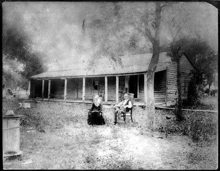
Haydon built a log structure about 1834 just west of Whitley's cabin that served as
a tavern and inn. (A picture of the Haydon tavern appears as Illustration 2 on p.
ii.) The tavern reportedly had
two rooms upstairs and two on the
(Page 11)
main floor. One
of the upstairs rooms was used by women travelers, and the other by men.* A short distance east
of the Haydon tavern--perhaps 30 yards--was a blacksmith shop. (23)
Both the Hayd
on tavern and the blacksmith shop were about 100 yards north of the present
east-west "old Whitley road" through the township. In the early and mid-1830's, however,
there were other primitive roads. One was a road from Charleston to Whitley Point. (24) Another was a north-east to south-west road called the Shelbyville and Danville
road, which was reportedly surveyed in 1833. (25) This road apparently ra
n through Whitley
Point** roughly parallel to the timber line which, according to the early federal
land survey, cut diagonally across the center of Section 12 in the late 1820's and
early 1830's.*** In the early twentieth century traces of this road
could still be
seen in Section 12. Travellers along this road coming from Danville or other points
northeast forded Whitley Creek near the original site of John Whitley's cabin and proceeded
southwest past the Haydon tavern and the blacksmith shop, and
on across what later
became known as the Whitley road in the direction of Shelbyville.****
An early store was also established at Whitley Point by Daniel Ellington, who was
said to be from Virginia and bought 80 acres of land near the Whitleys
, paying $100. (26)
Ellington became the first
* This two story structure was later used as a home by the John Vogel family until about 1918, when it was demolished.
** Indications of a road or trace between Shelbyville and Danville appear on several maps of Illinois from the 1830's through the 1850's. Although this road is imprecisely located--the maps show an approximate straight line connection between the two town
s--it appears to pass through or near the Whitley Point area. Peck & Messinger Sectional Map of Illinois, 1836; Peck & Messinger Sectional Map of Illinois, 1850; Peck and Messinger New Sectional Map of Illinois, 1852 (Illustration No. ___, p. ___) (showin
g road passing northwest of Whitley Point); Tanner Map of Illinois, 1833; Tanner Map of Illinois, 1841 (Illustration No. ___, p. ___).
*** See Illustration ___, Plat of Township 12, Federal Land Survey.
**** George F. (Fred) Edmonds, the present owner of the original John Whitley property and a long time resident of the area, wrote in the 1970's, "There used to be traces of the old Shelbyville Road crossing the back of my place; it ran in a south westerl
y direction, going near the old Whitley's Point Tavern ... I suppose all traces are gone now." (Radio program script of George Fred Edmonds, November 1977, files of Moultrie County Historical Society.)
(Page 12)
postmaster and kept the post office in his store, dispatching and receiving mail once a week, usually Saturday.* The store first operated by Ellington
was reported to be southwest of Haydon's tavern and on the south side of the present east-west road (27)--probably adjacent to the northeast-to-southwest Shelbyville and Danville road.
There were other buildings in addition to the tavern, blacksmith shop and store. I.J.
Martin (1859 1953), who g
rew up in the neighborhood, remembered much later the Whitley
Point settlement as a "long string of log houses built end to end with connecting
sheds or covered driveways.... There was a post office here, and one building served
as a church and school
room. There was a store in the room with the post office."
"Mr. Haydon was the merchant, the post master, and the school teacher." (28)
Today, nothing of these early structures remains above gr
ound. However, their location
in the northeast quarter of Section 12 can be determined with reasonable precision.
The Whitley Point settlement was never platted, which perhaps explains why Whitley
Point does not appear on the early maps of Illi
nois--the Darby map of 1828, the Burr
maps of 1834 and 1835, the Young maps of 1834 and 1836, the Tanner maps of 1833 and
1841, or the Peck & Messinger maps of 1836 and 1850. However, it was mentioned in one of
the leading guides to European emigra
nts during the 1830's, A Gazetteer of Illinois,
by J.M. Peck (Philadelphia, 1837), which listed "Whitley's Point" among the established communities of Illinois, and located it at "the head of Whitley's Creek, in Shelby
County, east of the Kaskaskia Rive
r, and fifteen miles northeast of Shelbyville.
The timber and prairie are good." (29)**
* Ellington married one of tavern keeper William G. Haydon's daughters, Harriet, in the late 1830's. He was a member of the Moultrie County Commissioners' court in 1846, and was later an associate justice of the first County Court, from 1849 to 1853. (Inv
entory Of The County Archives Of Illinois, No. 70, pp. 18, 76 77.) His wife died of typhoid fever in April 1852, and two of their children were taken by the same disease two years later. Ellington remarried and his second wife likewise died from typhoid i
n May 1855, after which Ellington left for Missouri to get away from the terrible disease and bad memories. (Hortenstine, E.D., "Essex, Ghost Town ...", Daily Journal Gazette, Mattoon, Illinois, September 1, 1955.)
Other towns listed in Peck's 1837 Gazetteer are: Shelbyville, the county seat of Shelby County, with "45 or 50 families" and six stores; Decatur, the county seat
(Page 13)
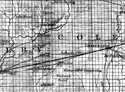
Whitley Point finally appeared on a map in 1852, when a revised Peck & Messinger map
of Illinois was published showing Whitley Point in the southeast corner of the county,
near the original 1826 settlement of John Whitley and his family in Section 1
2. (A
section of the 1852 Peck & Messinger map showing the area including Whitley Point is
reproduced as Illustration 6, above). Likewise, Whitley Point appears on the 1856
Chapman sectional map of Illinois.
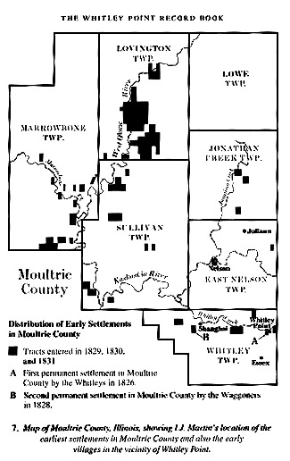
I.J. Martin also identified Wh
itley Point's location as in Section 12, at the east
end of what is now Whitley Township. (30) Martin had owned and operated an abstract
of title office, which provided sum-
________
of Macon County, with "about 30 families" and three stores; and Charleston, county seat of Coles County, which was laid out in 1831, with "about 25 families" and three stores. Other listed places in the vicinity of Whitley Point were Cochran's Grove, "a p
ost office and settlement" 10 miles east of Shelbyville; and Paradise, "a post office at the head of the Little Wabash ... on the road from Shelbyville to Charleston." Sullivan, of course, did not exist in 1837 and was not platted until 1845. Mattoon did
not come into existence until 1855.
(Page 14)
maries of real property records that formed the
basis of legal opinions as to the validity of title, so he had frequent occasion to examine
the earliest property records in Moultrie County. Late in his life, he prepared a
map of the county showing the
distribution of the early settlements from 1826 to
1831. On this map he located the Whitley Point settlement, described as the "first permanent
settlement in Moultrie County," in Section 12, Township 12N, Range 6E, just west
of the Coles-Moultrie count
y line. (A map showing I.J. Martin's location of Whitley
Point and other early settlements in the county appears as Illustration 7)
The recently-discovered Whitley Point record book itself contains on its first page
a notation by C.H. Bristow*
that the store whose record appears in the book was "at
what is now called the Old Hunt farm about 4 miles North East of Gays." Approximately
four miles northeast of Gays is where both the Peck & Messinger map of 1852 and the
later I.J. Martin map
of early county settlements located Whitley Point.
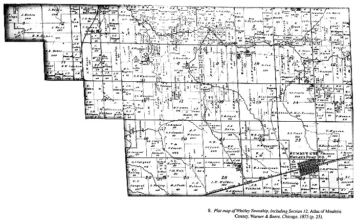
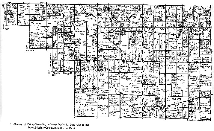
The earliest map or plat book of Moultrie County showing individual properties by
owner was published in 1875. The 1875 plat book does not show any location identified
as Whitley Point. But it
does show--in the east half of Section 12, next to the first
settlement by John Whitley and straddling the old Whitley road--a 140 acre property identified
as "J. Hunt's Est." (31)--almost certainly th
e "Old Hunt farm" referred to on the first
page of the record book as the store location. (The 1875 plat book page showing
the area including Whitley Point is reproduced as Illustration 8, For comparison,
a plat map of Whitley Township showing propert
y ownership as of 1995 is reproduced
as Illustration 9, p. 19.)
* According to Whitley township records, during the 1870's one S.P. Bristow was elected assessor (in 1872) and commissioner of highways (in 1879). An early Atlas of Moultrie County (Chicago, 1875) shows that S.P. Bristow in 1875 owned 80 acres of land jus
t south of the town of Gays, in Whitley Township, as well as 20 acres just north of Whitley Creek. And the 1870 United States Census identifies Samuel P. Bristow as 36 years old, with several children, including an 8 month old son named "Charlie H." Charl
es H. Bristow later married Mary E. Haydon, a granddaughter of tavern keeper and Justice of the Peace William G. Haydon, and lived in Sullivan where he was a broom maker. (Bristow, "Broom Making in Sullivan," Moultrie County Heritage, VIII, No. 2, May 198
0, p. 51.)
(Page 15)
 (Page 16)
George F. (Fred) Edmonds, a descendant of Jesse Hunt, has written that John Whitley
sold his property in the northeast quarter of Section 12 in the early 1830's to William
G. Haydon, who had earlier settled just south of Whitley. Then in 1852 Jesse Hunt
,
who had come from Kentucky, purchased both the Whitley and Haydon parcels from Haydon.
Hunt added acreage immediately to the west. When one of Hunt's daughters later married
J.M. Edmonds, Hunt transferred the original Whitley/Haydon parcels to his ne
w son-in-law. (32)
The 1875 plat book shows J.M. Edmonds as the owner of the Whitley/Haydon parcels,
and "J. Hunt's Est." as owner of the parcels adjacent to and west of Edmonds. The
1881 Co
mbined History says that John Whitley's first settlement was "on section 12,
where J.M. Edmond's farm now lies". And the 1875 plat shows a structure on the Edmonds
property--perhaps the original John Whitley cabin--in the center of the northeast qua
rter
of Section 12, north of the Whitley road and adjacent to Whitley Creek.
In addition to the maps and the 1875 plat book, E.D. Hortenstine, whose family resided
in the area for generations, wrote in 1955 that Whitley Point "was located a lit
tle
less than a half mile west of the Coles and Moultrie County line west of Mattoon
and one mile north of Western Avenue road." The Haydon tavern was "very close to where
John Vogel and Fred Edmonds now live." (
33) Long-time residents George F. (Fred) Edmonds
and Harold (Ben) Townley recall seeing the remains of the old Haydon tavern on what
is now the Voyles (formerly Vogel) farm in Section 12 north of the Whitley road in what
is now an open field. (34)
The present owners of the property are Mr. and Mrs. Marvin Voyles. Linda Voyles is
a granddaughter of John Vogel. They place the location of the Haydon tavern as just
north of the presen
t Vogel farmhouse in the west half of the northeast quarter of
Section 12 in what is now a cornfield. John Vogel and his family lived in the tavern building
until about 1918 when he tore down the old building and erected a new house a few
yards to the
south. Although nothing now remains of the original tavern structure
above the surface, when the building was demolished wood from the structure was used in
the construction of the new Vogel farmhouse, and part of the old tavern
(Page 17)
(Page 18)
(Page 19)
mantle piece
was saved by the Vogel family. Also, small chunks of the original foundation occasionally make their way to the surface as the Voyles farm the ground.*
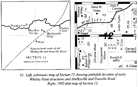
The recollections of these long-time residents together with C.H. Bristow's note
on
the record book confirm the location of the Haydon tavern, the store and other Whitley
Point business structures in Section 12. (A schematic map showing the creek as it
appeared in the 1875 atlas and the probable location of some of these structure
s is reproduced
as Illustration 10, above, along with a current map based on the 1995 county atlas.
Interestingly, the 1995 map shows Whitley Creek following a different course through section 12 than the 1875 atlas. By contrast, the 1821 Federal Survey
shows two
branches of the creek in section 12--one coming from the northeast, the other from
the east. (Illustration 4, supra, p. 7.)
* Knowledge of the location of the early blacksmith shop, which was a few yards east of the tavern, has likewise been passed on from generation to generation. (Interview with Mr. and Mrs. Marvin Voyles.)
(Page 20)
Of course, the Whitley Point community was more than the Haydon tavern and the other
buildings that served as blacksmith shop, store, post office and school. The early
settlers of the Whitley Point area were largely descendants of the group of colonists
once called Scotch-Irish and now referred to more accurately as North Britons, who settled
predominantly in the American backcountry of Pennsylvania, Virginia and North and
South Carolina. It was largely their descendants who settled southern and cent
ral
Illinois. Their pattern was to migrate in frequent short-distance movements as families
sought better conditions. As a leading scholar of this migration, Professor David
H. Fischer, has written, "The backcountry ideal was a scattered settlement pat
tern
in isolated farmsteads, loosely grouped in sprawling 'neighborhoods' that covered many miles." (35)
This was the pattern followed by the Whitley Point settlers who built their cabins
and laid thei
r claims in a "sprawling neighborhood" along a six-mile stretch of land on both sides of Whitley Creek and its tributaries, with the Whitleys at the eastern
"point" and the Waggoners at the west end.
Between the Whitleys and the Waggoners, appr
oximately four miles west of the John
Whitley cabin and Haydon tavern and south of the old Whitley road, was the Old School
Baptist Church near Lynn Creek. The congregation--the first in what is now Moultrie
County--was organized for the Waggoner famil
y by William Harvey Martin, who moved to the
Whitley settlement in 1829 from Kickapoo Point in Coles County. The twenty or so
members gathered in one of the Waggoner cabins until 1835 when the first church,
a hewed log structure was built by the members. (36) The first log church, built on the east side
of Lynn Creek, was a simple structure with one door and three windows. The seats
and floor were of "puncheon"--the logs split in two halves and place
d side by side
with the flat side up. Later, when the church building was used as a school house, a log was
removed from the west end to let in light to enable the children to read. (37) The log
church
was replaced by a frame building on the west side of the creek about 1860.
Neither the first log Baptist church nor its frame successor remains, but the Lynn Creek
church cemetery adjacent to the site of the later frame church is still maintained.
(Th
e older cemetery--adjacent to the site of the older, log
(Page 21)
church--is unenclosed and
in a field east of Lynn Creek owned by the J.R. Garrett family.) "Uncle Billy" Martin lived
on a farm near the log church and served as pastor until his death in 1852.
The frontier community of Whitley Point, like our
modern society, generated disputes
that had to be resolved. Civil disputes, including claims for money by one private
party against another, could be resolved by a Justice of the Peace; or, if sufficient
value was involved in the dispute, the case migh
t have to be resolved at first instance
by the Circuit Court. Criminal matters might likewise be tried before a Justice of
the Peace or a Circuit Court judge.
The first Justice of the Peace for the Whitley Point settlement and the surrounding
area was the first settler, John Whitley, Senior. Three other early justices were
the tavern owner William G. Haydon, Amos Waggoner and William W. Davis.
(Page 22)
|